My third day (second full day) in New England dawned cloudy…and drizzly…no sunrise…no sun at all. So at first light I decided to check out Sunday River Covered Bridge, near Newry, Maine, about 10 miles from where I was staying. I had been told in advance that this covered bridge was no longer “in service,” having been replaced by a modern bridge to allow traffic to cross the Sunday River. But the covered bridge itself is still quite photogenic. When I got there it was still raining, so I didn’t photograph the bridge; I put in on my list of places to return to as I determined that it would make a good subject from river level. But, while standing on the bridge itself, protected from the rain, I saw some trees along the river bank to the south that had started to turn.

Sunday River Color, Oxford County, Maine

Sunday River Color, Oxford County, Maine
When I determined, the night before, that it would be a cloudy morning, I decided to spend at least part of the day in Grafton Notch State Park. I worked out a driving circuit, heading north toward the notch on ME-5. On the way, under cloudy skies (but the rain having stopped), I passed a farm. Intrigued by what I saw, I stopped to check it out.

Cloudy Morning Farm, Oxford County, Maine
The morning mist hadn’t cleared from the mountains to the west; given the relative lack of color in the scene, I decided to convert this image to black and white.

Cloudy Morning Farm Black & White, Oxford County, Maine
Having captured the wider scene, I pulled out the telephoto rig to isolate the areas that really appealed to me–the tree-lined ridges and fog.

Morning Fog, Oxford County, Maine

Morning Fog, Oxford County, Maine
My next stop was Step Falls, a Nature Conservancy property just south of Grafton Notch. I arrived at mid-morning and had the place to myself.

Step Falls, Oxford County, Maine

Step Falls, Oxford County, Maine
While I was at Step Falls, the sun began to pierce the clouds. This was a portent of things to come as the clouds would, in short order, move off to the east for the rest of the day. Shortly before this happened, I stopped at Grafton Notch State Park to photograph the impressive Screw Auger Falls.
Before I got to the waterfall, I produced a quick shot of rapids along the Bear River.

Bear River Cascade Black & White, Grafton Notch State Park, Maine
Screw Auger Falls is a sectional waterfall that flows through a narrow gorge, not far from a marked parking area. After considerable investigation I found only one spot that I liked from which to photograph the falls. Reaching this location required a brief scramble up a boulder. From this position I produced several images.

Screw Auger Falls, Grafton Notch State Park, Maine

Screw Auger Falls, Grafton Notch State Park, Maine

Screw Auger Falls Black & White, Grafton Notch State Park, Maine
As you can see, the color in this area wasn’t very far along. So while I drove through the rest of Grafton Notch, I didn’t make any more images. (The by-now relatively harsh light had something to do with this as well.) I spent the rest of the morning scouting locations–all of the cascade or waterfall variety–located along East B Hill Road, west of Andover in Oxford County. This lonely road runs along a ridge and then, after a hasty decent, through a heavily wooded area. Before I descended the ridge I stopped to take one shot from the road, despite the light, just to demonstrate the view.

East B Hill Road, Oxford County, Maine
Most of my scouting time was spent traversing (without camera gear) a rather difficult trail to and from both tiers of Dunn Falls. Doing so required crossing a creek multiple times as part of a 3 1/2 mile loop. I determined it to be a waste of time. Lower Dunn Falls was impressive but, due to a huge log that had lodged in the splash area, unphotographable. Upper Dunn Falls could be photographed, but the limited water flow when I visited made it a pointless exercise in my estimation. I was glad that I hadn’t bothered to haul my gear on the fruitless trip.
It was mid-afternoon by the time I finished the scouting session and I decided to visit the nearby Lovejoy Covered Bridge–a spot I had located (after dark) on my first day in Maine. The bridge, located in South Andover, remains in service (i.e. it carries traffic). I checked the site carefully from both the road as well as at river level.

Lovejoy Covered Bridge, Oxford County, Maine

Lovejoy Covered Bridge, Oxford County, Maine
Next on the agenda I decided to climb up Bald Mountain, about thirty miles to the north, just west of Oquossoc, to investigate the view from the watch tower at the summit.
En route to Bald Mountain, heading north on ME-17, I spotted an intimate scene that caused me to stop and pull out my gear.

Autumn Intimate, Franklin County, Maine
Bald Mountain is located between Rangeley Lake (to the east) and Mooselookmeguntic Lake (to the west). I had been told that the 360-degree view was impressive…and that was true. The trail, however, was miserable. It’s steep (gaining 1200-odd feet of elevation to the summit in a bit more than a mile), but that didn’t bother me all that much. What did bother me was the nature of the trail. It was wall-to-wall roots and rocks over the first half-mile or so, but the remainder of the trail involved several locations that virtually required a scramble. That was annoying on the way up and damn near dangerous on the way down, given how slippery some of these spots were. Still, I made it up and back in one piece. And I did have the opportunity to enjoy the impressive view from the 30-foot high tower, which rises above the numerous mature spruce trees at the summit. There are no views at all from anywhere on the summit other than the tower. (The entire experience took about 90 minutes.)

Rangeley Lake from Bald Mountain, Franklin County, Maine
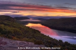
By the time I descended the Bald Mountain Trail, it was less than an hour until sunset. I decided to head back to Height of Land Overlook, which was only about 15 minutes away and on the way back to Rumford. Once again, I was hoping for a great sunset. It wasn’t great, but it wasn’t bad, either. Not by a longshot.
The light, just before the sun went down, was exquisite.

Mooselookmeguntic Lake from Height of Land Overlook, Franklin County, Maine
After the sun sank below the horizon, the color in the sky improved just a bit.

Mooselookmeguntic Lake from Height of Land Overlook, Franklin County, Maine
The shots that I found most graphic were those that I took with my telephoto lens.

Mooselookmeguntic Lake at Sunset from Height of Land Overlook, Franklin County, Maine

Mooselookmeguntic Lake at Sunset from Height of Land Overlook Panorama, Franklin County, Maine
And with that, a day that had started with clouds and rain ended with a mostly clear sky. Those conditions would change substantially overnight.


Looks like another interesting day. The photos at Screw Auger Falls and the last sunset light are my favorites. I’m always impressed that you are willing to negotiate slippery trails and rock scrambles when you are out on your own in relatively unpopulated areas. Take care out there!
By: EllenK on November 7, 2016
at 9:14 am
Thanks, Ellen. Every now and again a “what are you going to do if _____ happens” thought pops into my head when I’m running around one of these places. I honestly think it’s caused me to be more careful than I would otherwise be…most of the time, anyway.
By: kerryl29 on November 7, 2016
at 9:56 am
Some lovely shots!
By: centralohionature on November 7, 2016
at 9:19 am
Thanks!
By: kerryl29 on November 7, 2016
at 9:52 am
I was reading the above comments and admire your adventuresome spirit-that and careful planning is what gets you these awesome shots that you consistently take.I too like those warm sunsets and there is nothing like fall photos with the brilliant blue skies and colourful foliage.Always a treat to see covered bridges since they are becoming more rare these days.
By: Janes Heartsong on November 7, 2016
at 1:04 pm
Thanks very much, Jane. There will be a few more covered bridge images in future entries in this series.
By: kerryl29 on November 7, 2016
at 7:51 pm
Beautiful photographs Kerry……..The Screw Auger Falls images blew me away. They are gorgeous. I love reading your process of how you decide where to go, and the conditions that you encounter.
By: Carol Smith on November 7, 2016
at 3:00 pm
Thanks, Carol. Screw Auger Falls is a really attractive site; the only downside is the limited number of good spots from which to photograph it.
By: kerryl29 on November 7, 2016
at 7:58 pm
Wow, the second picture titled “Mooselookmeguntic Lake from Height of Land Overlook, Franklin County, Maine” is stunning! Totally belongs on a wall.
By: Israel's Good Name on November 8, 2016
at 9:24 am
Thanks!
By: kerryl29 on November 8, 2016
at 9:52 am
Wow, what fabulous shots and a spectacular place to take them. The colours are beautiful 🙂
By: seasiangirl on November 10, 2016
at 6:56 pm
Thanks very much!
By: kerryl29 on November 10, 2016
at 7:17 pm
Thanks for the glorious tour. Very inspiring.
By: karen on November 12, 2016
at 3:37 pm
Thanks very much!
By: kerryl29 on November 12, 2016
at 4:27 pm
[…] my time in New England this fall. You’ve already seen evidence of that, particularly during my days in Maine, but it was every bit as much the case during my adventures in Vermont and New Hampshire as […]
By: Thematic Interruption: An Ongoing Celebration of the Mundane | Lightscapes Nature Photography Blog on December 15, 2016
at 10:05 am
Great call on the B&W rendition of the Cloudy morning farm – the light! Another beautiful collection of images, Kerry.
By: composerinthegarden on December 31, 2016
at 7:08 pm
Thanks, Lynn!
By: kerryl29 on January 1, 2017
at 11:57 am
[…] quite impressive and I made a mental note to return late one day while I was still in the region. And so I did, near the end of the very next […]
By: The Story Behind the Image: Mooselookmeguntic Lake at Sunset | Lightscapes Nature Photography Blog on January 9, 2023
at 8:04 am
[…] quite impressive and I made a mental note to return late one day while I was still in the region. And so I did, near the end of the very next […]
By: The Story Behind the Image: Mooselookmeguntic Lake at Sunset - Photography on January 10, 2023
at 12:32 am