Prior to this trip, I knew very little about the region of Maine that I was visiting. I didn’t know anyone who had ever been there, let alone photographed there. I’d read a bit about it and had some direction about where to go once I was in the area, but there’s reading/hearing about a place and there’s seeing it with your own eyes. I knew that there would be a premium on scouting sites during the first day or two that I was on the ground in the region.
As I mentioned in the previous post, my plan was to photograph sunrise right from the grounds of my motel, which was situated on the north bank of the Androscoggin River. The overnight temperature was forecast to dip to the freezing mark and I figured that there would be copious fog coming off the river at daybreak. I wasn’t disappointed.
It was 31 degrees when I headed outside a bit before 6 AM (about 35 minutes before sunrise). There was just enough light at that point for me to be able to find my way around without a headlamp and I moved on to the back lawn of the property–the grass was covered with frost–and made my way the short distance to the edge of the river. As expected, fog was everywhere. I investigated my surroundings as best I could. The river was extremely slow-moving at this spot, which made for some workable reflections. There was a clear view spot along the bank that was surrounded by tall grass and a number of trees–mostly oaks–which were just beginning to turn. I worked out approximately where the sun would come up–assuming it would be visible through the fog–set up and waited for the light. It didn’t take all that long.

Androscoggin River Sunrise, Oxford County, Maine
Once the sun started to have an impact on the setting I moved around a bit, to use some of the trees and grasses as foreground elements. There was essentially no wind at all.

Androscoggin River Sunrise, Oxford County, Maine
Eventually, the sun rose high enough to burn off some of the fog–at least for a period of time–revealing part of the village of Rumford Center on the bank around a bend in the river.

Androscoggin River Morning, Oxford County, Maine
The fog actually thickened again, significantly, for a period of time.

Androscoggin River Morning, Oxford County, Maine
But eventually, the sun did its thing with authority.

Androscoggin River Morning, Oxford County, Maine
Before I left the spot, I took the time to work out a composition including one of the trees that had been behind my shooting position all this time.

Androscoggin River Trees, Oxford County, Maine
And when all of the fog had lifted in the direction of Rumford Center, I produced one shot of the trees, in full sunlight, on the hillside behind the town.

Emerging Color, Oxford County, Maine
After a bit more than an hour, I called it quits. I was more or less a popsicle at this point anyway. But I got in the car and headed in the same direction I’d gone the previous day when I visited Coos Canyon. The rest of the day was spent in the field, far from my sunrise shooting spot. There are no towns of any size where I was going. There are no gas stations between the twin towns of Rumford and Mexico (combined population: about 7500) at the northern end of my excursion, and Oquossoc (population about 160), roughly 50 miles to the north. Rangeley (pop. 1100) is another ten miles or so east. This is what it’s like in this part of Maine. There are very few towns or villages and what there is is mostly tiny (in terms of people and services).
I was headed in the direction of Rangeley Lake, about 50 miles to the north, but I made a number of stops along the way. One of the first of those stops was at Beaver Pond, which was situated right along the highway. The light was still pretty good when I was there, and it was just about dead calm, so I hauled out my gear and produced a few images.

Beaver Pond Morning, Franklin County, Maine
The color was just starting to pop at this location. I figured with two consecutive cold nights–and one more to come–I’d see considerably more color in the next few days.

Beaver Pond Morning, Franklin County, Maine
After Beaver Pond I checked out another pond which required about a two-mile round trip hike–Spencer Pond. There wasn’t much color there–partly because there wasn’t much change to the deciduous trees and partly because there were a lot of conifers surrounding the lake. This was the first of a number of scouting checks that more or less led nowhere during this day as I spent time investigating places like Ellis Pond and Loon Lake, only to be disappointed with the lack of access, lack of color, lack of shooting options or some combination of all of these factors.
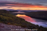
But I did stop and photograph at the Height of Land Overlook, about 10 miles south of the small town of Oquossoc, which is on the northwest edge of Rangeley Lake. Height of Land is a beautiful spot, overlooking Mooselookmeguntic Lake (no, that’s not a typo) to the west. Even though the light wasn’t all that great, I did make a couple of images from the overlook.

Mooselookmeguntic Lake from Height of Land Overlook, Franklin County, Maine
I spent a lot of time at this spot–the overlook runs for a couple of hundred yards–investigating different perspectives and determined to return at sunset. Then I moved a few miles down the road to the Rangeley Lake Overlook which provides views of–you guessed it–Rangeley Lake to the east.

Rangeley Lake from Rangeley Lake Overlook, Franklin County, Maine
I found this spot less enticing than Height of Land, partly because it’s not as high relative to the valley it’s overlooking and partly because the viewpoint isn’t anywhere near as close to the body of water at its base.
I continued north on ME-17 to Oquossoc and then east on ME-4 to the town of Rangeley. I poked around in a small park, which included a marina, right on the edge of Rangeley Lake, but almost all the boats were gone and I couldn’t make much of the spot. So, on this sunny day, I checked out a couple of nearby locations, including the Cascade Stream Trail, which included a number of waterfalls. I was impressed with what I found during my extended scouting session so I marked the spot and planned to return if I had a cloudy day. Then I found another overlook of Rangeley Lake, this one on the east side of the water, and I marked that as well for possible future reference and did the same with another Rangeley Lake vantage point that I discovered, this one at water level.
I also examined several ponds that were right off the road. By now it was well into the afternoon. I’d spent a lot of my time checking out dead ends, but I found both ponds to be worthwhile. The first was Harvey Pond. There was very little color here at this stage, less than I’d seen just about anywhere else in the Rangeley Lakes region, for some reason, but I liked the setting and the light. The lack of wind was a real bonus.

Harvey Pond, Franklin County, Maine

Harvey Pond, Franklin County, Maine

Harvey Pond, Franklin County, Maine
The other pond–Sandy River Pond–had much better color but limited access. But the color was so good–the best I’d seen up to that point, and, I judged, just a few days away from peak–that I plotted a return to this spot at the next available opportunity.
I then made my way south on ME-4 to Smalls Falls, which is located at a roadside rest stop. Most of the waterfall was still in open sun, but the upper tier was shaded, so I climbed up there and produced one image.

Smalls Falls, Franklin County, Maine
I then continued south to Mt. Blue State Park which contains, among other places, Webb Lake. It took me a bit of time to find it and by the time I did it was starting to cloud up for the first time this day. Eventually I did find the public access area of the lake and took some time to investigate the shoreline and photograph a bit.

Webb Lake, Mt. Blue State Park, Maine

Webb Lake, Mt. Blue State Park, Maine

Webb Lake, Mt. Blue State Park, Maine
There wasn’t much color at this spot, but I liked the compositional elements and decided to convert some of the images to monochrome.

Webb Lake Black & White, Mt. Blue State Park, Maine

Webb Lake Black & White, Mt. Blue State Park, Maine
It was less than an hour before sunset at this point and I had to determine whether, given the apparent increasing cloudiness, if it was worth trying to get back to Height of Land–which was probably 45 minutes away–or punt on sunset and perhaps go back to Smalls Falls and photograph in even light. (Staying at Webb Lake didn’t make much sense because my access point was east-facing.) I decided to make a run at Height of Land, on the theory that, if a sunset did materialize and I wasn’t in a position to take advantage of it, I’d kick myself. I could always go back to Smalls Falls in even light at a later time.
The shortest route back to Height of Land was over a series of unfamiliar (at least to me) roads. I hoped they weren’t unpaved…but they were. They were, however, well-graded, so with care I made my way back to the overlook about 10 minutes before the sun set. It was mostly cloudy, but there was a crack of clear sky near the horizon, so I hoped I’d get something appealing. I did, though it was by no means epic.

Mooselookmeguntic Lake at Sunset from Height of Land Overlook, Franklin County, Maine

Mooselookmeguntic Lake at Sunset from Height of Land Overlook Panorama, Franklin County, Maine
At one point, I whipped out the telephoto lens and tightened up on the area of sky with the greatest amount of color.

Sunset, Height of Land Overlook, Franklin County, Maine

Sunset Panorama, Height of Land Overlook, Franklin County, Maine
I hoped that some more of the clouds might light up after the sun was completely down, but it wasn’t to be. What you see above was as vibrant as anything I saw, and after that the sky just faded into gray. And with that, the photography day was over and I made the roughly hour-long drive south on ME-17 back to where I was staying.
There was one more piece of excitement, however. This is moose country; there are warning signs all over the place and I was on high moose alert while driving. I had my high beams on whenever possible, but, about 25 minutes after the sun went down, I was rounding a curve in the road and saw something in the gloaming ahead of me, off to the right side of the road. I couldn’t tell what it was until I was just about on top of it; it was a huge bull moose. Fortunately he stayed off the road and I stayed in one piece. Phew.


Great photos, especially the morning ones!
By: gaurav1729 on October 31, 2016
at 9:54 am
Thanks!
By: kerryl29 on October 31, 2016
at 7:58 pm
Love them all. I’m learning a lot from your blog!
By: writely2015 on October 31, 2016
at 10:30 am
Thanks very much; I’m thrilled to hear that you’re finding the blog worthwhile.
By: kerryl29 on October 31, 2016
at 7:59 pm
Just stunning!
By: HermitCrab on October 31, 2016
at 11:01 am
Thanks!
By: kerryl29 on October 31, 2016
at 8:00 pm
Stunning photos.
By: Beautywhizz on October 31, 2016
at 11:12 am
Thank you!
By: kerryl29 on October 31, 2016
at 8:00 pm
Fantastic shots of a wonderful landscape. I bet it must be hard to choose only a few after such a trip …
By: Dina on October 31, 2016
at 12:02 pm
Thanks! Yes, going through all the images after a trip like this can be quite an exercise.
By: kerryl29 on October 31, 2016
at 9:22 pm
Deer are bad enough, but a moose! Whew! Another batch of fine photos, Kerry. I especially like the ones with the sun battling the fog.
By: Tom Robbins on October 31, 2016
at 12:40 pm
Thanks, Tom. Yeah, that near-encounter with the moose was quite an experience.
By: kerryl29 on October 31, 2016
at 9:24 pm
Looks like a productive day. I especially like the morning fog photos…and being able to walk out the door and have that scenery before you must have been quite special.
By: Ellen Kinsel on October 31, 2016
at 9:11 pm
Thanks, Ellen. Yes, that was a good photography session. (Spoiler alert: I did it again on the morning of the fifth full day. Stay tuned. 🙂 )
By: kerryl29 on October 31, 2016
at 9:26 pm
Great series of autumnal images…all great but love the intro shot
By: davidoakesimages on November 1, 2016
at 4:36 am
Thanks!
By: kerryl29 on November 1, 2016
at 10:44 am
Great set but the morning light was just superb, particularly the first image.
By: leecleland on November 1, 2016
at 5:07 am
Thanks very much!
By: kerryl29 on November 1, 2016
at 10:44 am
[…] There was no chance of a sunrise. I made my plans–based on the scouting that I did on Day 2–to take advantage of the soft […]
By: New England Day 4: Mostly Cloudy | Lightscapes Nature Photography Blog on November 14, 2016
at 8:08 am
[…] Pond for sunrise. This would be my third visit to this location, having previously been there on Day 2 and Day 4. The trees surrounding the pond were approaching peak and I had determined that the […]
By: New England Day 5: Northward | Lightscapes Nature Photography Blog on November 29, 2016
at 8:23 am
[…] a better spot than right on the motel property alongside the Androscoggin River, as I had done on Day 2. Once again, fog on the river and first light were cooperative, even though it wasn’t quite […]
By: New England, Day 6: Transitions | Lightscapes Nature Photography Blog on December 5, 2016
at 8:30 am
Kerry, these are exquisite. Many mirror images here with the water reflections, which I love – they have a surrealistic dreamlike quality. The first Androscoggin River Sunrise image is especially evocative and nuanced, as is the Webb Lake image with the reeds – a study in horizontals. I swear Kerry, your images grow ever more beautiful each year.
By: composerinthegarden on December 31, 2016
at 6:59 pm
Thanks very much Lynn; that’s extremely kind of you.
By: kerryl29 on January 1, 2017
at 11:57 am
[…] the northwest part of Maine, with no more than a rough itinerary in place. This was, in fact, my first full day on the ground in the region and much of that time was spent just getting a kind of lay of the land. […]
By: The Story Behind the Image: Mt. Blue State Park | Lightscapes Nature Photography Blog on July 17, 2023
at 8:01 am