When I think of Day 4 of my trip to Hawaii this past September I’m invariably reminded of dialogue from an episode (“Chief Surgeon Who?”) broadcast during the first season of the television series M*A*S*H. In that episode, a visiting general has some choice words for Frank Burns:
Gen. Barker: Can I make a suggestion about Major Burns? Give him a high colonic and send him on a 10-mile hike.
Hawkeye: With full pack.
Gen. Barker: Nice touch.
While I skipped the high colonic, I did go on a ten-mile–and then some–hike…yes, with full pack. But I’m getting ahead of myself.
I had planned this hike for one day–without being specific about exactly which day–during my time on Kauai. It was the weather forecast, and the weather on previous days, that forced my hand. This very long day hike, along a pair of ridges penetrating the Na Pali Coast in Koke’e State Park, was a purported ten miles in length with thousands of feet of elevation loss, and then gain. It required dry weather, not only for the day of the hike, but preferably for several days prior to the hike. Why? Avoidance of mud. I detailed what the Kalalau Trail was like when wet, but that trail involved relatively little elevation gain/loss. Those kinds of conditions on this hike would make it nearly impossible to carry out.
The weather had been dry for several days in the Koke’e area, but the forecast going forward was for a significant chance of rain for the next…well, for as many days as remained in the forecast, spanning the duration of my time on Kauai and then some. And, this significant chance of rain was supposed to begin by early afternoon of the day I was going to carry out the hike, i.e. Day 4. If I was going to do this hike, I was going to have to do it on this day and start as early as possible. This meant breaking in my new pair of hiking boots on an all-day hike–not an ideal set of circumstances, but I really had no choice, other than to forego the hike entirely.
What was the alleged payoff? Spectacular, essentially otherwise unattainable views of Kauai’s Na Pali Coast. This was something I didn’t want to miss.
So, with all of that in mind, I decided to go to Waimea Canyon for sunrise, then make the relatively short (about 10 minutes) drive to the trailhead in Koke’e State Park and begin this lengthy hike as early as possible.
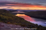
I had been to Waimea Canyon on Day 2, so I had the benefit of knowing how early I would have to arise to make it to the Waimea Canyon Lookout on time for dawn. (Answer: about 4:15 AM.) I ended up arriving just as the light was coming up in the sky–a bit later than I would have liked, but, as it turned out, in plenty of time to catch dawn and the ensuing sunrise. There was one other photographer at the lookout in the chilly, and somewhat windy, morning conditions when I arrived but we stayed entirely out of one another’s way as he favored a spot that I found utterly unappealing. (He presumably had the same thoughts about my chosen location.)

Sunrise, Canyon Lookout, Waimea Canyon State Park, Kauai, Hawaii

Sunrise, Canyon Lookout, Waimea Canyon State Park, Kauai, Hawaii

Sunrise, Canyon Lookout, Waimea Canyon State Park, Kauai, Hawaii.

Sunrise, Canyon Lookout, Waimea Canyon State Park, Kauai, Hawaii

Sunrise, Canyon Lookout, Waimea Canyon State Park, Kauai, Hawaii
When the sun crested the canyon rim, I quickly gathered up my things and made a beeline to the trailhead parking area for the Nualolo Trail.
The hike I had planned actually included three trails that, taken together, make a kind of a loop. It’s not technically a loop because you end up at the trailhead of the third trail and have to walk roughly two miles on the Koke’e park road to get back to your vehicle. The hike starts with the Nualolo Trail, which runs approximately four miles from the trailhead out to what is known as Lolo Vista, a cliffside point with views of the Nualolo Valley and a major chunk of the Na Pali Coast. The trail drops approximately 1700 feet in elevation, and while it descends fairly steadily it’s not particularly steep until the hiker reaches a segment in the final mile. About a mile from the end, the trail intersects with the Nualolo Cliffs Trail which serves as a connector with the Awa’awapuhi Trail to the northeast, which has its own vista point, about one half mile below the intersection with the Cliffs Trail. The Awa’awapuhi Trail is a bit more than three miles in length with more than 1600 feet of elevation change. It is relentless in its ascent and descent, though it’s never particularly steep.
For a variety of reasons, it’s recommended to do the loop in a clockwise direction, that is, starting with Nualolo, then the Cliffs connector, then down to the Awa’awapuhi overlook, then back up the full length of the Awa’awapuhi Trail, then, the park road back to the Nualolo parking area. I’ve seen all kinds of vague estimates of the total distance of this hike, assuming one does it in the manner just described and goes down to both lookout points. I have calculated the distance as roughly 12.6 miles. That’s my story, and I’m sticking to it.
So, I got to the Nualolo parking area, which was deserted, naturally enough, about 30 minutes after sunrise. I quickly applied sunscreen and took a liter-sized bottle of water, a few things to eat, pared my photo backpack down to one (!) camera body and two lenses (24-70 and 80-400) and hit the trail. Why the paring down? Did I mention the 12.6 mile hike? The large bottle of water? The combined elevation change on the three trails of roughly 4000 feet? Yes? Well, that’s why.
I saw no one on the Nualolo Trail, at any point. I was told that the trail could be overgrown in spots and, sure enough, it was. My bare legs (too warm for long pants/long sleeves, I decided–and, was I ever right about that) ended up getting somewhat cut up by some of the overgrowth, but it was nothing serious. The trail down, for almost all of the first three miles, is through a series of ecosystems, including thick forest, grassy areas, what almost resembled high desert, and three or four other types of landscape. Quite interesting, but not particularly photogenic, in my opinion. Besides, it was sunny this entire time, and the light was far from ideal considering the growth I was going through. Since the trail was almost entirely downhill, I didn’t stop until I was near the end and, thus, made very good time.
After reaching the junction with the Nualolo Cliffs Trail, just under one mile from Lolo Vista, the trail gets steeper and opens up with views of the valleys on both sides of the ridge. You realize, almost instantly, what a narrow spine you’re traversing at this point. Eventually, you’re perched on a ribbon of dirt, peering down into the Nualolo Valley to your right, and you begin to catch a glimpse of some excellent views of the mysterious Na Pali Coast. Moving on to Lolo Vista itself–there’s a sign, essentially telling you that you’re there–you’re treated to the promised views: the reason why you went to all of this trouble in the first place.

Na Paii Coast from Lolo Vista, Nu’alolo Trail, Koke’e State Park, Kauai, Hawaii

Na Paii Coast from Lolo Vista, Nu’alolo Trail, Koke’e State Park, Kauai, Hawaii

Na Paii Coast from Lolo Vista, Nu’alolo Trail, Koke’e State Park, Kauai, Hawaii

Na Paii Coast from Lolo Vista, Nu’alolo Trail, Koke’e State Park, Kauai, Hawaii
This was also a good spot to pick out abstracts of the fascinating pali (i.e. cliffs) that give the Na Pali Coast its name. I made considerable use of my telephoto lens at this point.

Pali Shadows, Na Paii Coast from Lolo Vista, Nu’alolo Trail, Koke’e State Park, Kauai, Hawaii

Pali Shadows Black & White, Na Paii Coast from Lolo Vista, Nu’alolo Trail, Koke’e State Park, Kauai, Hawaii

Pali Shadows, Na Paii Coast from Lolo Vista, Nu’alolo Trail, Koke’e State Park, Kauai, Hawaii

Pali, Nu’alolo Trail, Koke’e State Park, Kauai, Hawaii

Pali Black & White, Nu’alolo Trail, Koke’e State Park, Kauai, Hawaii

Valley Shadows, Nu’alolo Trail, Koke’e State Park, Kauai, Hawaii
After admiring the views from the area around Lolo Vista for some time, I retraced my steps on this steep section of the Nualolo Trail to the point where the Nualolo Cliffs Trail junctions. This pathway is one of the most overgrown trails I’ve ever hiked. I counted 11 downed tree trunks across the trail (which runs two miles), all of which I was able to clear, with varying difficulty. This trail isn’t particularly steep, but it can, in spots, be extremely difficult to follow. Nualolo Cliffs traverses some extremely lush areas, as the below photo demonstrates. It was as I was nearing the end of the Cliffs Trail that I encountered my first hikers of the day–a couple that was doing the loop in the opposite direction. We chatted briefly and I was then on my way.

Nu’alolo Cliffs Trail, Koke’e State Park, Kauai, Hawaii
I reached the Awa’awapuhi Trail eventually and made the relatively short half-mile hike down to the lookout point. There’s a guard rail at one point, which represents the official viewpoint, from which you can see absolutely nothing. I did stop at this spot for some water. While I was there, several red-crested cardinals–presumably looking for a handout–dropped by.

Red-Crested Cardinal, Awa’awapuhi Trail, Koke’e State Park, Kauai, Hawaii
The Awa’awapuhi Trail clearly gets more traffic than the Nualolo Trail, presumably because it’s roughly one-mile shorter; that’s one-way. As an out-and-back, the Awa’awapuhi Trail is two miles shorter than the Nualolo Trail, which is an obvious benefit. It’s also in much better shape (there are no overgrown sections of the Awa’awapuhi Trail) and, while more relentless in its incline/decline, isn’t as steep in its worst sections. Still, when I got to the “official” lookout point, there was no one else there. I could see a (presumably unofficial) trail leading down from this official lookout spot and, though it was quite steep, I made it down this relatively short section with no real difficulty. The section ends at a spot with some nice views.

Na Pali Coast, Awa’awapuhi Trail, Koke’e State Park, Kauai, Hawaii

Pali, Awa’awapuhi Trail, Koke’e State Park, Kauai, Hawaii

Pali, Awa’awapuhi Trail, Koke’e State Park, Kauai, Hawaii

Na Pali Coast, Awa’awapuhi Trail, Koke’e State Park, Kauai, Hawaii
You can go further on this trail, if you dare. The image below shows the promontory that you have to cross to do so. That small connector at the bottom is about two feet wide. To the left, is a drop of about 15 feet to a grassy area which falls away fairly rapidly. If you fell off to the left, you’d probably live to tell the tale. The fall off to the right is about 2000 feet straight down; there’s no grassy area…or, more accurately, if there is, you’re 2000 feet above it.

Na Pali Coast from the, Awa’awapuhi Trail, Koke’e State Park, Kauai, Hawaii
I started to cross this small footbridge, carrying my heavy pack and my tripod…and my brain absolutely wouldn’t let me do it. It was one of the strangest experiences I’ve ever had. I simply could not cross that narrow passage. I mean…I’ve hiked the Angel’s Landing Trail at Zion National Park in Utah. Twice. I didn’t have anything like this experience. I decided that at least part of the problem had to be the fact that I don’t have nearly the sense of balance when I’m hauling a heavy pack–and carrying a tripod in my hands–as I do when I’m unencumbered (center of gravity being what it is). So I set both backpack and tripod down and was able to overcome the stumbling block…crossing the small “bridge” with relatively little difficulty. But to obtain even more views, you have to go over the high point you see in the above image and the area where I’d left my things is completely out of sight if you do so. You can’t see it again at any point further along (and it gets even hairier in spots further down that ridge). There also really isn’t anywhere worth taking a picture of where you can set up a tripod. While I was down there dealing with all of this, some other hikers came down to where I was and, since I didn’t want to leave my things unattended I retreated back across the “bridge” to the previous spot.
I spent quite a bit of time at this location–on the “safe” side of the precipice, with my backpack and tripod. What I concluded, based on what I’d seen, was that while this spot had some really fascinating views, they didn’t really make for particularly fascinating landscape images. For a variety of reasons, this was one of those “good views don’t necessarily make good photographs” situations (a subject I mused about in an entry I posted several years ago).
I kept waiting for people to leave, so that I could take another look over the ridge without worrying about what I was leaving behind, but more people kept showing up. A goodly number of them couldn’t bring themselves to step across that narrow “bridge,” even while carrying next to nothing. I could understand why, after I thought about it for a bit. There was no way to safely walk across that narrow, uneven area–it’s not remotely flat, not incidentally–without looking down to make sure where you’re stepping. And when you do that, guess what you see? That’s right, the cliffside, inches from where you want to step, and the dizzying site of the valley floor, 2000 feet below. And if that bothers you…you’re not going to be able to make it across. And it’s pretty normal to be bothered by something like this. I realized later, that I could have gotten around the problem that *I* had–which was limited to trying to make it across with the weight of all of my things–if I’d sat down on the rocks and scooted across while carrying my pack and tripod. But that would have been pointless because, as I’d seen on the other side, there was really no place wide enough to set up a tripod that was worth doing so, certainly not without blocking someone else’s ability to get by.
Eventually, I retreated back up the steep mountainside to the “official” viewpoint, where I drank the remainder of the water I’d brought…and it was at this point that a light rain began to fall. It had been growing increasingly cloudy, just as forecast, for the past hour or more. I decided that it was time to clear out. I’d read that the Awa’awapuhi Trail–to say nothing of Nualolo–could be extremely difficult to traverse when wet, so I set off. The hike out was not pleasant. It rained–never very hard–off and on for the entire remainder of the hike. The trail was okay–not really slippery at all, I suppose because it had been dry for several days and the rain was so light. But, having already hiked the better part of eight miles that day and still dragging around a heavy pack up a relentlessly uphill trail that was gaining an average of 500 feet of elevation per mile…let’s just say that I’ve had more enjoyable experiences.
I did stop, briefly, on the way up, during a lull in the rain, to photograph a ferny area that I found captivating. In a sense, recognizing the photo opportunity despite all the stress served as validation that my neurons were still firing.

Fern Forest, Awa’awapuhi Trail, Koke’e State Park, Kauai, Hawaii
About 1.5 miles before the trailhead, I started dreaming of water. I had already sweated through my clothes two or three times that day and I was out of water, naturally. I was, in short, kind of running out of gas, but I pushed on without pausing. I reached the trailhead and prepared for the two mile hike, in the light rain, on the park road back to my car. I had to dodge cars on the road, of course, but it was nice to be walking on a paved surface that only undulated a bit, rather than hiking up a steep trail filled with rocks and tree roots. On the park road, I met the couple I’d run into on the Nualolo Cliffs Trail. They were heading to their own vehicle, which was parked at the Awa’awapuhi parking area.
I got back to the car, completing the nearly 13-mile hike, and immediately drained one of the four bottles of water I’d left there. It was now about 3 PM, about eight hours after I’d started the hike. I drove out of Koke’e, through Waimea Canyon State Park and, eventually, all the way down to the highway in the town of Waimea. What to do with the last few hours of daylight?
It was cloudy now, and shortly after I reached the highway, a heavy rain squall blew through. I decided that, given how close I was, I would try to make my way out to Polihale State Park, which is at the end of the road, at sea level, on the southwest part of Kauai. The beach at Polihale came recommended and I wanted to check it out. I figured that I’d try to shoot sunset out there, even though it wasn’t looking very promising for a good sunset. I’d driven out of the rain squall–and it clearly hadn’t rained in this area as I neared the road to Polihale–but it was still almost entirely cloudy.
I got to the Poilhale turnoff and was greeted by a sign saying that this was an “unimproved road” and drivers took it at their own risk. Not a good start. I then encountered the single most pothole-filled road I think I’ve ever driven. I was never concerned about getting stuck or breaking down, as long as I drove slowly….but I mean five miles an hour slowly. Any faster, without a true high clearance vehicle, was really pushing it. The road to the beach is five miles long…and I kept hoping it would get better, but after a mile and-a-half, it was at least as bad as it had been at the beginning. I did some quick math. Five miles an hour meant it would take an hour just to get out to the beach. And it would take another hour to get back. It was at least another hour’s drive back to Kapa’a, where I was staying, on the main highway (probably more, actually). And if I stayed out at the beach for sunset, I’d have to make the drive back on this pitiful excuse of a road in the pitch dark. And it still looked like sunset wouldn’t be great. That was that…I turned around.
So, it was pushing 5 PM, less than 90 minutes before sunset, by the time I got back to the main highway. Now what? I decided to check out Kekaha Beach, just a few miles back on the road, in the direction I was ultimately headed anyway. The beach was directly accessible from parking strung out along the southern edge of the highway. The only area of the sky that wasn’t cloudy was directly across the beach, to the south. It was just about perfect. And this was where I spent the rest of the day until the light was gone completely.

Kekaha Beach, Kauai, Hawaii
There was one section of beach that was covered by naupaka, which made for a very interesting foreground.

Kekaha Beach, Kauai, Hawaii

Kekaha Beach, Kauai, Hawaii
The beach itself runs for miles in this area, and I moved along to the west to investigate the reflections available from a lagoon I’d spotted.

Sunset Reflections, Kekaha Beach, Kauai, Hawaii
The beach was nearly devoid of people–I could literally see a total of a handful of subjects–so I made my way down near the surf to try and make something of the last 20 or 30 minutes of ambient light as the sun sank to the horizon amidst a plethora of clouds to the west.

Kekaha Beach at Sunset, Kauai, Hawaii

Kekaha Beach, Kauai, Hawaii

Kekaha Beach, Kauai, Hawaii

Kekaha Beach at Dusk, Kauai, Hawaii
That this hadn’t exactly been the most sensational sunset I’d seen on Kauai validated my decision not to deal with the Polihale road, but I was still pretty pleased with the day’s events, including my early evening foray to Kekaha Beach. I’d made it through the travails of the long Koke’e hike in one piece. My hiking boots hadn’t filled my feet with blisters (and, just importantly, the boots themselves hadn’t fallen apart). All of my cardio training on a stair climber (more on this, perhaps, in a separate entry) had paid off in that I was confident that I would still be able to function the next day after the physical strain of this one.
I made the trek back toward Kapa’a in the dark somewhat satisfied, but with a pressing question…what was I going to do with the remainder of my time (three full days plus one morning) on Kauai?


Great blog post, check out my newly published article on my blog, thank you
By: TinyJeremy on November 25, 2019
at 11:08 am
Thanks!
By: kerryl29 on November 25, 2019
at 11:16 am
The views from the hike are amazing and worth the effort. I won’t lecture on the lack of water issue, but it concerns me. And ONE camera…this is definitely a departure from the norm.
By: EllenK on November 25, 2019
at 11:18 am
I actually brought about twice as much water as I normally take, even on a fairly long hike, and I was pretty sure I was skimping. Still, given the length and strenuous nature of the hike, I really wanted to keep the weight down…and water’s pretty heavy. This was also the rationale behind leaving one camera body (and one lens–the one that ended up malfunctioning later in the trip) behind.
Overall, I think it was the right call. I probably shed 10 pounds between the remaindered gear and water, so I was hauling closer to 25 pounds (including tripod/head, etc., which I had strapped to the backpack for essentially the entire hike) than 35. And still, that climb out wasn’t much fun. I don’t even want to think what it would have been like with the extra weight.
By: kerryl29 on November 25, 2019
at 11:37 am
Wow! What gorgeous pictures! Hopefully those views made it worth the effort. I’ve been there with running out of water on a strenuous hike. Not fun!
By: M.B. Henry on November 25, 2019
at 4:30 pm
Thanks!
I pretty much knew, when I started out on that hike, that I wasn’t going to have an ideal amount of water with me. I just hoped I had enough to get me back without any repercussions and, in the end, I did.
By: kerryl29 on November 26, 2019
at 10:14 am
Amazing story and photos. Never have seen a cardinal like that.
By: Jane's Heartsong on November 25, 2019
at 10:26 pm
Thanks, Jane.
I don’t believe the red-crested cardinal has any presence on the North American mainland. It’s native to South America–and southern South America at that–though it has been introduced to Hawaii and Puerto Rico.
By: kerryl29 on November 26, 2019
at 10:18 am
Hi, would love for you to check out my blog and let me know what you think ☺️
By: Isha on November 28, 2019
at 11:09 am
[…] and reservation limitations had caused me to do my two longest planned hikes on the second and third full days on Kauai. But I still had three full days–and the morning of a fourth–left […]
By: Hawaii Day 5: Plugging Gaps | Lightscapes Nature Photography Blog on December 2, 2019
at 9:08 am
After all my travels I just caught up by reading day 3 through 5. I had to LOL on your Polihale unimproved road comments. Many years ago, I think it was 1987 or so, my rental car was a Fiero. Well I took it all the way to the end of the road. I returned the car to the rental car company minus the rear bumper which just basically fell off on the way back on that road.
By: E.J. Peiker on December 2, 2019
at 10:27 am
How did the rental car company react to that? Hopefully insurance covered the damage.
It sounds as though the road to Polihale–and I use the term “road” in its broadest possible connotation–hasn’t improved in the last 30+ years. I never had the sense that I would break down, as long as I traveled very slowly, but there was absolutely no way to avoid the infinite, huge potholes. I can’t imagine covering the length of that road in the dark (i.e. after sunset).
By: kerryl29 on December 2, 2019
at 7:46 pm
As I recall I had to pay like a $200 deductible.
By: E.J. Peiker on December 2, 2019
at 8:48 pm
[…] lens and went off to photograph the geese, without spooking them. I had seen nene during my 13-mile hike in Koke’e State Park, but I didn’t have the opportunity to photograph […]
By: Hawaii Day 7: Finding Something New | Lightscapes Nature Photography Blog on December 23, 2019
at 10:05 am
This trek looks like it was absolutely unreal!
By: travelersandhikers on December 29, 2019
at 8:26 am
Thanks! Yes, it was quite a hike.
By: kerryl29 on December 29, 2019
at 8:26 pm
Amazing pictures! That sounds like quite the hike.. I’ve definitely gone on hikes before thinking it was one length and realizing whoever said it was that short was entirely confused. Haha
By: Jade on January 23, 2020
at 12:22 pm
Thanks. It was definitely a lengthy hike, but not really longer than I had been led to believe. It was, however, at least a bit more overgrown (in places) than I anticipated. That plus the incessant uphill climb on the back end, when I was already eight miles into the hike with brand new hiking boots (etc., etc.) is what made it a bit of a slog.
By: kerryl29 on January 23, 2020
at 1:01 pm
[…] of photographs obtained. While an experience like the one at Coyote Gulch a few years ago, or the epic Kauai hike, may have been quite memorable because of the exertion, the photographs were no “better,” no […]
By: A Question of Worth | Lightscapes Nature Photography Blog on June 19, 2023
at 8:02 am