Since I had nearly 550 miles of driving–more than 80% of it not on Interstate highways and including clearing two high mountain passes–facing me on this day, I figured that the photo opportunities would be limited…and so they were.
I left Oakley, Kansas nearly two hours before daybreak, reached Colorado Springs by mid-morning and, by around noon, was crossing Monarch Pass on US-50 heading west. Shortly before reaching Monarch Pass–which was more or less at peak color when I went through–I stopped at a spot in the San Isabel National Forest that I noticed from the road and made my first images while in Colorado during a brief pause between rain drops.

Aspens, San Isabel National Forest, Colorado

Aspens, San Isabel National Forest, Colorado

Aspens, San Isabel National Forest, Colorado
I drove over Monarch Pass, through the town of Gunnison, through the Curecanti National Recreation Area, over the (relatively) low Cerros Pass and reached the junction with US-550 in the town of Montrose by mid-afternoon. From there, it was about an hour south to the town of Ouray, which brought me to the last leg of the journey–the 21-odd mile drive over Red Mountain Pass to the small town of Silverton where I would be baesd for the next few days.
The drive over Red Mountain Pass is pretty eventful under the best of circumstances. The pass itself is more than 11,000 feet above sea level and the section of US-550 that accesses it is steep, winding and mostly devoid of guardrails. By the time I reached the town of Ridgway, about 10 miles south of Ouray, it was raining, lightly but steadily. When I hit Ouray it was a moderate steady rain; the air temperature was about 40 F. Ouray is situated at about 7800 feet above sea level, so the trip up to the pass from Ouray–which is 10 or 11 miles–involves an elevation increase of more than 3200 feet. You can probably see where this is going…
Just north of Ouray, in the early stages of the trip up to the pass, the rain increased in intensity. Water was cascading down the steep mountainsides–which, at this point of the trip, run right alongside the highway to the east–and pouring across the road. By the time I was about halfway up to the pass, I was beginning to see signs that the rain was changing to sleet and shortly thereafter, as the temperature continued to drop with the elevation increase, it was coming down as a heavy, wet snow. Within a short time, the snow was sticking on the pavement as well as the side of the road and when I got to within a mile or so of the pass itself, it had already accumulated to the tune of three or four inches. We crawled along–I was stuck behind a huge RV, with Florida plates, no less–and then, just below the pass, we came to a full stop, smack in the middle of a steep hairpin turn. I noticed motorcycles (!) abandoned along the side of the road. Why people were trying to drive motorcycles over Red Mountain Pass when it had been raining–hard–below, is beyond me, but the full stop was caused by a group of motorcyclists who were abandoning their bikes and boarding an RV which was presumably going to take them down the mountain.
I mentioned that this drive is a pretty iffy one for many people, even when the road is bone dry. People with a fear of heights often find it difficult, bordering on impossible, to make the drive given the proximity to long drop-offs and a lack of guardrails. These conditions were anything but bone dry. I’ve driven in snowy conditions so many times over the years that I’ve lost count…but in snowy conditions on steep, windy mountain roads (while following an RV with Florida plates)? Not so much. But I was careful (as, apparently, was everyone else on the road). We cleared the pass and began the somewhat shorter descent to Silverton (elevation approximately 9300 feet) and, ultimately, the snow turned back into rain by the time I reached town.
It was no more than two hours before sunset when I reached Silverton; shortly after I got there, the precipitation stopped and, after the long drive, I was itching to get out with my camera. I headed back in the direction of Red Mountain Pass, but stopped before I got very far to photograph an area overlooking the South Fork of Mineral Creek.

South Mineral Creek, San Juan National Forest, Colorado
I continued back to the south, gaining elevation the entire way, and reached an area a few miles below the pass where it had been cold enough to snow earlier. I made heavy use of the telephoto lens at this location.

Snowy Red Mountain Pass, San Juan National Forest, Colorado

Snowy Red Mountain Pass, San Juan National Forest, Colorado

Snowy Red Mountain Pass, San Juan National Forest, Colorado

Abandoned Mine Site, Red Mountain Pass, San Juan National Forest, Colorado
The clouds kept rolling in and out, periodically revealing breaks of clear sky.

Snowy Red Mountain Pass Black & White, San Juan National Forest, Colorado

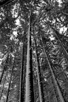
Snowy Conifers, Red Mountain Pass, San Juan National Forest, Colorado
Eventually I made my way to a spot just a few hundred feet below the pass where an unofficial pull-out provided access to some 270-degree views of snow-covered conifers and mountain peaks.

Snowy Red Mountain Pass, San Juan National Forest, Colorado

Snowy Conifers Black & White, Red Mountain Pass, San Juan National Forest, Colorado

Snowy Conifers, Red Mountain Pass, San Juan National Forest, Colorado

Snowy Conifers at Sunset, Red Mountain Pass, San Juan National Forest, Colorado
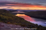
By this time it was no more than 15 minutes until sunset. I got back in the car, drove just past the pass and parked on the side of a road near a small tarn, part of which was covered with ice. Still, in the open water part of the pond, the reflections were captivating. I moved to the north end of the tarn and, facing more or less due south, waited for what light might come.

Tarn at Sunset, Red Mountain Pass, Uncompahgre National Forest, Colorado

Tarn at Sunset, Red Mountain Pass, Uncompahgre National Forest, Colorado

Red Mountain Pass at Sunset, Uncompahgre National Forest, Colorado
That brought the day’s photography to an end. The next morning would be my first full day on site and I was determined to make the most of it. I planned to spend daybreak at Crystal Lake, about five miles south of Red Mountain Pass. I was counting on being able to make the drive, in the dark, on this icy mountain road…


nice
By: simonjkyte on November 28, 2017
at 9:10 am
Thanks!
By: kerryl29 on November 28, 2017
at 10:24 am
The orange, yellow, and green trees in the snow at Red Mountain Pass make a very nice image. The sunset reflections in the tarn are also lovely.
By: EllenK on November 29, 2017
at 12:33 am
Thanks, Ellen!
By: kerryl29 on November 29, 2017
at 12:06 pm
Are you sure these are photos? They look like paintings! Absolutely gorgeous photography.
By: Luna on November 29, 2017
at 12:24 pm
Thanks very much!
By: kerryl29 on November 29, 2017
at 3:01 pm
Excellent prose and compelling photos. Well done, Kerry. 🙂
By: Frank King Photos on December 2, 2017
at 7:09 am
Thanks very much, Frank!
By: kerryl29 on December 2, 2017
at 10:06 am
Sweet! Love how the colors popped out and separated from each other. Awesome……
By: ddhester on December 2, 2017
at 5:23 pm
Thanks!
By: kerryl29 on December 2, 2017
at 5:29 pm
Pretty intrepid driving there, Kerry! I’ve driven roads like that under similar conditions, but have to say I’d just as soon not do it again! The images were more than worth it though! Marvelous!
By: Gunta on December 3, 2017
at 9:15 pm
Thanks, Gunta!
Yeah, even though I’ve driven on snowy/icy roads more times than I can count, this was a bit hairy–windy, steep, virtually no guardrails…
By: kerryl29 on December 3, 2017
at 9:53 pm
PS We discovered a favorite Thai restaurant in Brookings, so it’s become a bit of a ritual to stop for a walk at Myers Beach. Caught a very nice sunset there tonight, but haven’t posted anything yet.
By: Gunta on December 3, 2017
at 9:58 pm
I’ll look forward to seeing it when you get a chance to post…
By: kerryl29 on December 3, 2017
at 10:01 pm
What a drive, but as Gunta said, worth it. The second & third from last photos are fantastic, such pretty colors!
By: bluebrightly on December 4, 2017
at 2:54 pm
Thanks very much!
By: kerryl29 on December 5, 2017
at 11:37 am
Glad you made generous use of unofficial turn-outs along the highways. We have plenty of them.
Not envious of your drive through Red Mountain Pass. Invariably, there are a few accidents due to conditions once the snow begins to fly. Abandoning motorcycles, though, is a new one for me. Real bikers tend to lay back and let the weather pass through rather than ride through heavy rain or through snow. The lack of guardrails reminds me of my niece who prefers not to drive SH 67 to Cripple Creek from Divide because of that; she goes there through the back way. Driving behind an RV with Florida plates does not stoke anyone’s confidence about driving through a windy mountain road in snowy conditions.
Gorgeous photos, BTW; especially liked the abandoned mine. There are a “countless” number of abandoned mines throughout SW Colorado.
By: David on December 5, 2017
at 12:33 pm
Thanks, David.
Re US-550 over Red Mountain Pass, I was told by someone on the ground there that there are a couple of fatalities on that stretch of road just about every winter (in blizzard conditions, apparently). The thing with the motorcycles was unbelievable to me. The fact that it had been raining, steadily, in Ouray should have been reason enough not to take a bike up that road. Some of those motorcycles were still there as much as two days later, by which time all trace of snow on the road was gone.
No indeed, being behind a Florida-plated huge RV (the kind that’s built on a bus chassis) was definitely not confidence inspiring, but all things considered the driver actually handled the situation pretty well.
I photographed several abandoned mine sites while I was on the ground there, some of which will be revealed in my next post.
By: kerryl29 on December 5, 2017
at 9:34 pm
Beautiful photos!🙂
By: The Thrifty Campers on December 6, 2017
at 4:19 pm
Thanks very much!
By: kerryl29 on December 6, 2017
at 5:03 pm
[…] in a brilliant, entirely clear sky and as I nudged the vehicle onto the road and headed back toward Red Mountain Pass, I noticed that the tire pressure warning sensor was illuminated on the […]
By: Colorado, Day 2: Frosty Morning | Lightscapes Nature Photography Blog on December 11, 2017
at 8:10 am
[…] approximately 10,200 feet above sea level, it was snowing lightly. Not wanting to be caught in another potential snowstorm, I decided it was time to retreat back to lower elevations, so I returned in the direction of […]
By: Colorado Day 10: Further Explorations | Lightscapes Nature Photography Blog on February 26, 2018
at 8:34 am
I recall clearly that beautiful winding drive between Ouray and Silverton, and also the mine-site. It was mid October and I’m glad we drove it on a dry day. Even though I too am familiar and experienced with driving in snowy conditions, and we have a small AWD, I generally avoid these conditions by checking the weather first, then finding an alternative route if necessary or slowing down and waiting for conditions to change. Of course you’re look for varied conditions. In part 10, as you muse, what were those motorcyclists thinking? This is a wonderful series of posts and I learn much in reading and studying them Kerry. Thanks.
By: bruce thomas witzel on February 26, 2018
at 11:53 am
Thanks, Bruce!
The drive between Ouray and Silverton…it can be pretty hairy. But there really is no practical alternative route to crossing Red Mountain Pass. The shortest alternative involves driving all the way down to Durango via Lizard Head Pass (and if weather is a problem at Red Mountain Pass it may very well be at Lizard Head as well, though the route isn’t nearly as gnarly), and then come back through Coal Bank and Molas Pass (ditto on the weather). That would be a detour, in dry conditions, of several hours. In bad weather, it could take the better part of a day, assuming that the passes are traversible. Best bet if you have to get from Ouray to Silverton and the direct route is a problem is to simply wait it out in Ouray.
As for the motorcyclists…I have no idea what those people were thinking.
By: kerryl29 on February 26, 2018
at 3:56 pm
When my wife and I travel we try to look for where the weather is nicest, and sometimes this takes us in opposite direction, even a state or two over. But when in the mountains the weather can change so quickly, even in seemingly good weather. Some day I’d like to travel the complete San Juan Skyway. Cheers – Bruce
By: bruce thomas witzel on February 27, 2018
at 11:19 am
“Some day I’d like to travel the complete San Juan Skyway.”
Me too. That had, in fact, been my plan, and I did cover the entire length of the circuit from Durango north to Ridgway, east and south to Telluride, all the way to about five miles south of Lizard Head Pass. But for the remainder of the route–south through Rico and Dolores, all the way back to Durango…didn’t make that part of the journey, due to poor conditions at the tail end of the trip.
By: kerryl29 on February 27, 2018
at 12:29 pm
[…] Ocean. The pass is roughly 4700 feet above sea level, which doesn’t seem particularly high (Red Mountain Pass, in the Colorado Rockies, is more than 11,000 feet by comparison), but at this latitude–more […]
By: Alaska: Atigun Pass Snowfall | Lightscapes Nature Photography Blog on October 9, 2018
at 10:29 am
[…] The trip over the pass was the most harrowing experience of the day. I described the events in an entry and will re-post a bit of the description […]
By: The Story Behind the Image: Snowy Sunset Tarn | Lightscapes Nature Photography Blog on January 13, 2020
at 9:55 am