That cloudy weather that was ubiquitous on Day 7? That was the forecast for Day 8 as well. But there’s cloudy and then there’s cloudy. You know, the kind of gloomy overcast day with no definition in the clouds. The kind of day that’s so dark it appears that it will start raining at any moment. That is the kind of weather forecast for Day 8…and the forecast was accurate.
I decided to spend the day in a location that was well-suited for the weather conditions, so I headed south on I-93 to Franconia Notch State Park in New Hampshire–about a 30-minute drive from St. Johnsbury. A guidebook that I’d purchased before the trip gave me some details about a couple of trails in the park filled with waterfalls and streams–good subjects for overcast conditions, as I constantly preach.
My first stop was the Falling Waters Trail, which has three waterfalls on it in addition to the stream (Dry Brook). This is a very popular route up to the Ridge Trail in the White Mountains. Even on a day like this–with absolutely no visibility above perhaps 2000 feet due to the low cloud cover–there was still plenty of traffic. The waterfalls all lie in the first couple of miles on this fairly steep trail, and I was only planning to go up as far as the top of the third cataract (Cloudland Falls).
Dry Brook parallels–and occasionally crosses–the trail and I started out by noting some opportunities to photograph the waterway below the waterfall. I made one photograph:

Dry Brook, Falling Waters Trail, Franconia State Park, New Hampshire
I decided to wait until the return trip to actually shoot these spots. I then made my way up the trail to the first of the waterfalls: Stair Falls, the smallest of the three falls on the route.

Stair Falls, Falling Waters Trail, Franconia State Park, New Hampshire
Not much farther along the trail is Swiftwater Falls.

Swiftwater Falls, Falling Waters Trail, Franconia State Park, New Hampshire
The rocky surface immediately below the falls was remarkably slippery so I was very careful with my footing as I investigated some alternate compositions.

Swiftwater Falls, Falling Waters Trail, Franconia State Park, New Hampshire
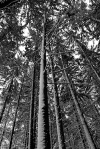
As you can see, many of the trees along this trail are conifers, so there isn’t an abundance of color. The waterfalls, however, are quite photogenic including 80-foot Cloudland Falls, the better part of a mile farther along the trail from Swiftwater.

Cloudland Falls, Falling Waters Trail, Franconia State Park, New Hampshire
I spent a fair amount of time at this location, exploring a number of different spots.

Cloudland Falls, Falling Waters Trail, Franconia State Park, New Hampshire

Cloudland Falls, Falling Waters Trail, Franconia State Park, New Hampshire
I climbed the steep, slick trail above Cloudland Falls. On the way up, I found a spot from which I wanted to photograph the waterfall, but it was a very narrow ledge and given the traffic on the trail, I decided to wait for the trip back down to try to produce the photo.
I resumed the climb up the trail and produced a few shots of Dry Brook above Cloudland Falls.

Dry Brook, Falling Waters Trail, Franconia State Park, New Hampshire
I then began the descent of the trail, but stopped at that small ledge to produce the image of Cloudland Falls that I’d identified a bit earlier.

Cloudland Falls, Falling Waters Trail, Franconia State Park, New Hampshire
When I got down near the trailhead, I returned to the spots along Dry Brook that I’d found on the way up.

Dry Brook, Falling Waters Trail, Franconia State Park, New Hampshire

Dry Brook, Falling Waters Trail, Franconia State Park, New Hampshire

Dry Brook, Falling Waters Trail, Franconia State Park, New Hampshire
It was early afternoon by the time I got back to my car and I made the short drive to the parking area for the Basin-Cascades Trail, a several mile-long trail that includes a couple of waterfalls and excellent access to Cascade Brook.

Basin-Cascades Trail, Franconia State Park, New Hampshire
I spent about four hours investigating photo opportunities along the trail. One particularly interesting feature is “The Basin.” I spent a fair amount of time fine-tuning compositions of this unique spot.

The Basin, Basin-Cascades Trail, Franconia State Park, New Hampshire

The Basin Black & White, Basin-Cascades Trail, Franconia State Park, New Hampshire
I continued along the trail and found many compelling locations.

Basin-Cascades Trail, Franconia State Park, New Hampshire

Basin-Cascades Trail, Franconia State Park, New Hampshire

Basin-Cascades Trail, Franconia State Park, New Hampshire

Basin-Cascades Trail, Franconia State Park, New Hampshire
Eventually I arrived at the first of the two “major” waterfalls along the trail: Kinsman Falls.

Kinsman Falls, Basin-Cascades Trail, Franconia State Park, New Hampshire

Kinsman Falls, Basin-Cascades Trail, Franconia State Park, New Hampshire
Kinsman Falls is tucked into a notch with a sizable splash pool so I spent most of my time investigating the surrounding environment with particular emphasis on the foreground.

Kinsman Falls, Basin-Cascades Trail, Franconia State Park, New Hampshire

Kinsman Falls Black & White, Basin-Cascades Trail, Franconia State Park, New Hampshire
The end of my journey on this trail was Rocky Glen Falls. This waterfall was difficult to see; the only decent viewpoint lies between two large rocky edifices. I played around with a couple of different compositions.

Rocky Glen Falls, Basin-Cascades Trail, Franconia State Park, New Hampshire

Rocky Glen Falls, Basin-Cascades Trail, Franconia State Park, New Hampshire
I captured one intimate fall color scene right at the Basin-Cascades Trail parking lot.

Fall Color, Basin-Cascades Trail, Franconia State Park, New Hampshire
With only about an hour of daylight remaining I made the relatively short drive to the Lost River area of White Mountain National Forest. The color in this area was excellent and I spent the short time I had left before it became completely dark capturing some images.

Fall Color, Lost River, White Mountain National Forest, New Hampshire

Lost River, White Mountain National Forest, New Hampshire

Fall Color, Lost River, White Mountain National Forest, New Hampshire
And with that, the day came to an end. Day 9 would be spent back in Vermont, covering quite a bit of ground, but before chronicling that experience, in the next post I’ll describe a special source of information I was able to utilize to help me find locations while in Vermont.


Beautiful work! Thank you for sharing these lovely falls with us!
By: karineverhartphotography on December 27, 2016
at 9:49 am
Thanks very much!
By: kerryl29 on December 27, 2016
at 10:04 am
Beautiful shots Kerry; lovely country in all weather conditions. I’ve hiked Franconia Ridge on eastern side of this valley and it’s a workout. Thx for sharing!
By: Mike Hohmann on December 27, 2016
at 11:12 am
Thanks, Mike!
A troop of boy scouts and their leaders stopped to talk with me while I was photographing Cloudland Falls. They were absolutely determined to hike up to, and beyond, Little Haystack Mountain, despite the total lack of views. I hiked up above the falls and by that point the fog/cloud cover was so thick that visibility wasn’t more than a couple of hundred feet, and there was absolutely no hope of getting above the clouds. The only reason to keep going, as far as I was concerned, was for the workout and I’d get that later in the day.
By: kerryl29 on December 27, 2016
at 11:44 am
I repeat to myself: Cloudy day, find waterfalls, Cloudy day, find waterfalls.Lovely series.
By: Janes Heartsong on December 27, 2016
at 6:30 pm
Thanks very much, Jane!
By: kerryl29 on December 27, 2016
at 11:59 pm
[…] https://lightscapesphotography.wordpress.com/2016/12/27/new-england-day-8-franconia-notch/ […]
By: Favorite Trails for Photography Part III | Lightscapes Nature Photography Blog on August 13, 2018
at 9:02 am